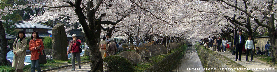
The Asian River Restoration Network was established in Nov. 2006 to support the exchange of information relating to environmental restoration of rivers and watersheds. JRRN has a role of ARRN secretariat currently.
Go to ARRN website

< World's WATERFRONT:JAPAN Category: Hokkaido >
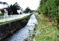
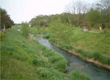
Before
(source: RFC)
|
|
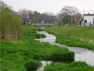
After
(source: RFC)
|
|
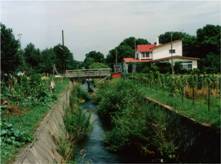
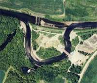
Before restoration project
|
|
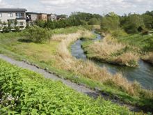
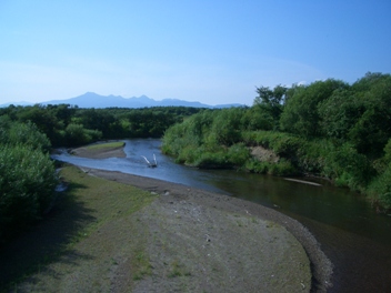
7 years after project (Upper reaches)
|
7 years after project (Middle reaches)
(source: Iwao Araseki)
|
Moizari River, a tributary stream of Izari River in Eniwa City, used to be a rich creek where salmon spawned. The river improvement construction was done from the 1950s straightening the river course and using the triple-phase method to keep the nearby farms away from floods, but the succeeding rapid city development lowered the flood control safety level. In 1986 the river improvement was restarted, which was certified in 1990 as the second “Hometown river model project” in Hokkaido. Various nature-based methods were introduced with the theme of “waterfront with no makeup,” integrating the river with nature and greenery. River-walk has also been prepared as a part of human-nature symbiotic city development.
>>More details (PDF 112KB)
By JRRN-secre | Category: Community and urban river restoration,Hokkaido | Comment(0) | Trackback(0) |
Date: 2012.03.29 18:12
Ishikari Plain has been changed to a vast agricultural land by embankment works and the agricultural land development conducted since the Meiji Period. As a result, the wetland spread in the low-lying area of the basin and the forests along the river were lost, the shape of the river was simplified and the ecological environment was dramatically deteriorated.
In order to regenerate the lost river environment of Ishikari River, pools are being constructed (which are or will be connected to the main stream when the water level increases) to diversify the river, restore the wetland environment and regenerate the forest environment at the meeting point between Ishikari River and Tobetsu River, a tributary river.
By JRRN-secre | Category: Nature oriented restoration,Hokkaido | Comment(0) | Trackback(0) |
Date: 2011.09.10 17:52
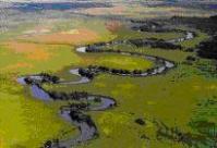
Shibetsu River has experienced constructions to straighten its winding stream to lower its underground water level, aiming at preventing flood and at better drainage of the basin, which was originally a peat district. Changes of the times have changed Shibetsu River’s requirements. With the local people’s voice asking for a better environment, Hokkaido Regional Development Bureau is working on a nature-restoring river development plan, aiming at restoring the nature-abundant original river conditions. In order to research the effect of straightened streams, the winding streams are partially restored as an experiment.
>>More details (PDF 51KB)
By JRRN-secre | Category: Nature oriented restoration,Hokkaido | Comment(0) | Trackback(0) |
Date: 2011.03.31 18:13
Kushiro River
(source: RFC)
|
The natural wetland environment of Kushiro River, which is a registered wetland designated under the Ramsar Convention in 1980, has deteriorated because of the land development in the surrounding area, the increased amount of sediment flowing into the wetland caused by the straightening of the inflow rivers and the lowering of the water table.
The "Kushiro Wetland Natural Environment Regeneration Project," is being conducted mainly by the Ministry of Land, Infrastructure, Transport and Tourism and Ministry of the Environment to rehabilitate and conserve the wetland by restoring the meandering streams to their original state and controlling the wetland vegetation.
>>More details (PDF39KB)
By JRRN-secre | Category: Nature oriented restoration,Hokkaido | Comment(0) | Trackback(0) |
Date: 2011.03.31 18:11
|
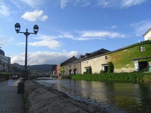
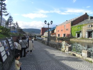
Current condition(Photo by Michiya Tannai, Aug. 2009)
|
Otaru Canal was completed in 1923 as a port facility. As it was constructed by reclaiming offshore other than by digging inland, it is characterized by a gently-curved shape in a fan-like form other than a straight-line shape. It played the important role of loading and unloading cargoes between ships berthed in the port and warehouses. However, in postwar days, the mission was ended because the pier of the port was constructed.
In 1986, after the controversy as to whether to reclaim it or not over ten-odd years, part of it was reclaimed, half of the canal in width was changed into a road and walkways and parks were constructed. In this way Otaru Canal was regenerated into the present form. In the walkways, 63 gas lamps were built and the stone warehouses along the canal were conserved as they were. At nightfall gas lamps are lit and the stone warehouses are lit up and an atmosphere different from that in the daytime can be seen.
By JRRN-secre | Category: History and traditional restoration,Hokkaido | Comment(0) | Trackback(0) |
Date: 2010.09.10 18:42
In Sarobetsu Plain registered under the Ramsar Convention in 2005, the land becomes dry progressively due to the agricultural land improvement for developing dairy and arid plants such as sasa veitchii are increasing in number. The lowering water level of the marsh caused by a drainage project for bogs along with the agricultural land development is another problem.
Under the circumstances, the Sarobetsu natural regeneration project toward “coexistence of marsh and agriculture” is being conducted to recover the drying marsh and conserve the marsh by providing buffer zones in the agricultural land.
By JRRN-secre | Category: Nature oriented restoration,Hokkaido | Comment(0) | Trackback(0) |
Date: 2010.09.10 17:55
Utonai Lake located near the confluence of Bibi River and Yufutsu River was registered under the Ramsar Convention in 1991. On the periphery of the lake, a rich natural environment including wildernesses and wetlands has formed. It is also a treasury of animals and plants and a wild paradise to which migrant birds such as swans arrive in flocks.
However, the valuable natural environment and the ecosystem is vanishing due to the land development around the basin, causing a reduction of the volume of the spring in Bibi River, dryness of the marginal environment, outflow of soil, water quality deterioration, a decrease of the wetland area, vegetation change, etc.
Today, a natural regeneration project is being conducted to restore the state of Bibi River and Utonai Lake seen in the 1960s and 70s based on four pillars: recovery of the volume of the spring in Bibi River, improvement of the spring quality, recovery of the current speed and river channel and recovery of the wetland environment around Utonai Lake.
By JRRN-secre | Category: Nature oriented restoration,Bay and lake restoration,Hokkaido | Comment(0) | Trackback(0) |
Date: 2010.09.10 17:53