< World's WATERFRONT: JAPAN TOP >
|
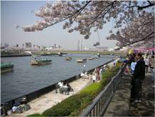
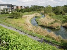
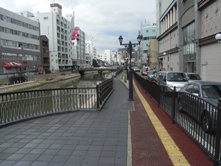
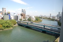
Current condition (Source: source: Tokyo Metropolitan Gov.)
|
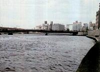
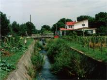
Sumida River around 1967
(source: Tokyo Metropolitan Gov.)
|
|
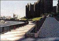
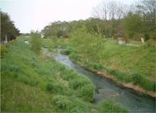
Current condition
(source: Tokyo Metropolitan Gov.)
|
Before
(source: Tokyo Metropolitan Gov.)
|
|
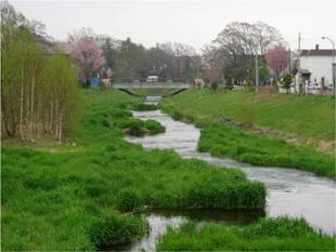
After
(source: Tokyo Metropolitan Gov.)
|
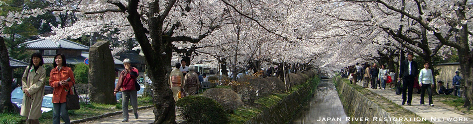
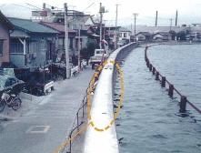
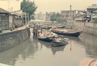
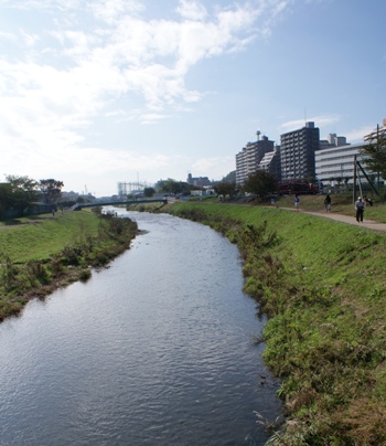
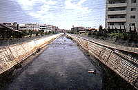
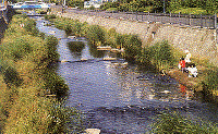
Postwar Sumida River waterfront was occupied by factories and warehouses, was deteriorated like a ditch, and was shunned by people. At the same time, industrial and logistical structure changes sap the area’s vitality as a production base. But increasing interest in environment headed for the semi-ruined city waterfront and a possibility of its restoration emerged and city-and-river development started, thus attractive urban area was gradually created.
The water quality of Sumida river was remarkably low in 1950s because of the industrial/domestic wastewater generated from rapid industry development and urbanization. However, after the Olympics held in Tokyo in 1964, the water quality was significantly improved by popularization of sewage water treatment system and more stricted restrictions.
Sumida river is characterized by 1) general river slope which promotes stagnant area 2) large effect of sea water that goes upstream 3) 60% of river water is treated sewage water. Therefore, efforts are being made to improve the water quality by modifying sewer system and introducing advanced waste water treatment.
In Asian nations with worsening river environments, Sumida River, improving after experiencing 50-year deterioration is a leading example in Asia.
>>More details, “River Rehabilitation with a focus on the Sumida River”(ARRN 4th International Forum held in 2007)
>>More details (PDF 50KB)
By JRRN-secre | category: Community and urban river restoration,Kanto | Comment(0) | Trackback(0) |
Date: 2012.03.31 18:34
|
Before Restoration Project
|
|
Photo by Michiya Tannai, May 2008
|
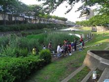
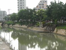
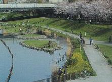
Izumi River flowing north and south longitudinally in Seya and Izumi Wards of Yokohama City is positioned as an important river in Yokohama’s river environment improvement project called the “Community River Improvement project.”
In the first half of the ’90s, basic research related to animals and plants in watershed areas of Izumi River was conducted for preparation of river restoration and scenery and a land utilization program was launched while preserving biological resources.
Today, Izumi River attracts a great deal of attention from people engaged in river restoration work as a good case example of reproducing diversity of the river from the viewpoint of the waterfront ecological system and landscape and river utilization by citizens although it is an urban river. In 2005, this project won the highest design award of the Japan Society of Civil Engineers’ Design Prize.
By JRRN-secre | category: Community and urban river restoration,Kanto | Comment(0) | Trackback(0) |
Date: 2012.03.30 16:19
Before
(source: RFC)
|
|
After
(source: RFC)
|
|
Before restoration project
|
|
7 years after project (Upper reaches)
|
7 years after project (Middle reaches)
(source: Iwao Araseki)
|
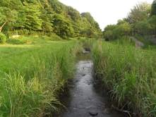
Moizari River, a tributary stream of Izari River in Eniwa City, used to be a rich creek where salmon spawned. The river improvement construction was done from the 1950s straightening the river course and using the triple-phase method to keep the nearby farms away from floods, but the succeeding rapid city development lowered the flood control safety level. In 1986 the river improvement was restarted, which was certified in 1990 as the second “Hometown river model project” in Hokkaido. Various nature-based methods were introduced with the theme of “waterfront with no makeup,” integrating the river with nature and greenery. River-walk has also been prepared as a part of human-nature symbiotic city development.
>>More details (PDF 112KB)
By JRRN-secre | category: Community and urban river restoration,Hokkaido | Comment(0) | Trackback(0) |
Date: 2012.03.29 18:12
|
Photo by Michiya Tannai, Aug. 2008
|
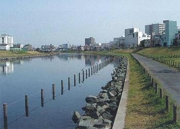
Hakata River running through Hakata and Tenjin districts at the center of Fukuoka City gave off a terrible smell and gas in the past due to deteriorated water quality as it was a tidal river without flow. Therefore, reclamation was discussed from time to time. In 1990, Fukuoka City developed the “Hakata River Dream Corridor Project” (“Hakata River Improvement Concept”), and this environmental improvement (including waterfront improvement) project has been promoted while urban area redevelopment project is conducted in addition to river environment improvement.
By JRRN-secre | category: Community and urban river restoration,Kyushu | Comment(0) | Trackback(0) |
Date: 2012.01.05 16:18
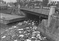
|
Photo by Norio Nagai, May. 2008
|
Murasaki River flowing through the inner-city area of Kitakyushu City was listed as a “My Town, My River Improvement Project (A Waterfront Plan project)” river in 1988. Since then, urban infrastructure improvement including river and surrounding urban development has been conducted. In the Murasaki River Bashaku district, various approaches are adopted, which include not only flood control projects but also waterfront park and road improvement and urban district vitalization to enhance private developers’ potentiality to create a town centering on the river.
By JRRN-secre | category: Community and urban river restoration,Kyushu | Comment(0) | Trackback(0) |
Date: 2012.01.05 16:18
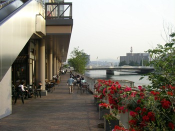
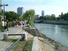
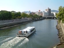
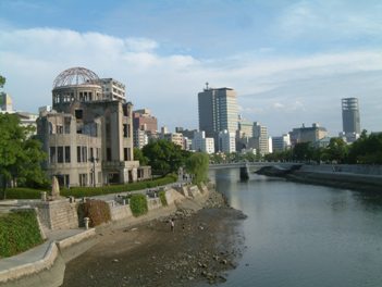
|
Photo by Yumi Imanishi, Sep.. 2007
|
For Ota River flowing though Hiroshima City, the national, prefectural, and city governments together developed a framework called “A Lagoon City of Hiroshima” in January 2003 to take progressive approaches toward the regeneration of a lagoon city in the green river area expanded in the postwar period. In this framework, three pillars of “to use,” “to create,” and “to connect” are provided to take the lead in social experiments in waterfront utilization and conduct waterfront restoration activities with the collaboration of citizens, companies, and government.
By JRRN-secre | category: Community and urban river restoration,Chugoku | Comment(0) | Trackback(0) |
Date: 2012.01.05 16:17
|
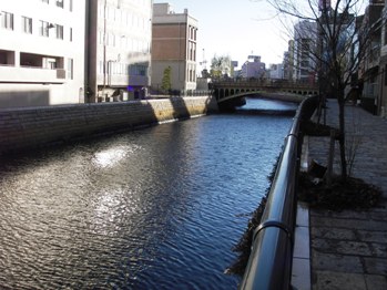
Photo by Akira WADA, Oct.. 2007
|
Along Oh River (previously called Yodo River), improvement of city parks, water bank protection, and docks has been carried out toward the creation of an urban environment having an affinity for water. In Osaka Amenity Park, in particular, a waterfront space appropriate to the lagoon city of Osaka is provided based on the concept of “creation of a complex city space well equipped with amenities and full of water, greenery, and light.”
By JRRN-secre | category: Community and urban river restoration,Kinki | Comment(0) | Trackback(0) |
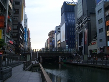
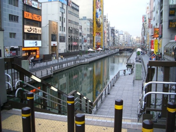
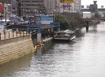
Date: 2012.01.05 16:16
|
Photo by Masafumi Ito, June 2006
|
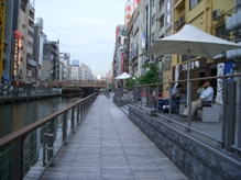
For Dotonbori River or the river representing Osaka, the walking trail has been improved as part of a project to regenerate “the lagoon city of Osaka,” by which people can feel familiar with water. By improving the flood gates that have the functions of water purification, tide prevention, and lockage, waterfront environmental improvement in the peripheral areas has been achieved.
By JRRN-secre | category: Community and urban river restoration,Kinki | Comment(0) | Trackback(0) |
Date: 2012.01.05 16:15
|
Photo by Susumu Domon, Jan. 2006
|
|
Source: RIVER FRONT vol.54
|
Regarding Hori River flowing north to south through the center of Nagoya City, there were industrial areas consisting of many factories and warehouses along the river and urban areas full of commercial facilities and residences built with their backs to Hori River. Additionally, the water quality was very deteriorated, which led to diminishment of the vibrant atmosphere. In this situation, a movement to regenerate Hori River, or the mother river of Nagoya, flourished and the river was listed as a “My Town, My River Improvement Project (A Waterfront Plan project)” river in June 1988. Since then, the Hori River restoration project has been conducted by the Nagoya City government and the local citizens.
By JRRN-secre | category: Community and urban river restoration,Chubu | Comment(0) | Trackback(0) |
Date: 2012.01.05 16:14
|
Before restoration (1960’s)
|
|
After restoration
|
After restoration
Source: Sep. 2006 Tokyo Metoropolitan Govt.
|
In watershed areas of the Old Naka River, because the surrounding ground is low, a river development project has been conducted to lower the water level to prevent flooding. Together with this project, highly water-attracting, beautiful waterfront spaces have been regenerated without damaging the river environment.
By JRRN-secre | category: Community and urban river restoration,Kanto | Comment(0) | Trackback(0) |
Date: 2012.01.05 16:13
Before(1970s)
(source: Tokyo Metropolitan Gov.)
|
|
After
(source: Keihin Office of River)
|
Tama River, with Ogouchi Dam (called Okutama Lake), completed in 1957, and with tourist facilities, has been a relaxation and recreation area for Tokyoites. But its midstream and downstream in Tokyo and Kanagawa have been urbanized as residential and industrial areas. During the high-growth period in 1965-75, its water quality was deteriorated and the variety of the water usage increased. Residents gradually needed more orderly space usage.
Recently natural life has returned to the area as the sewage system penetrated and the water quality improved.
>>More details (PDF 109KB)
By JRRN-secre | category: Nature oriented restoration,Kanto | Comment(0) | Trackback(0) |
Date: 2012.01.05 16:13
Before restoration (1972)
Source: Tokyo Metoropolitan Govt.
|
|
After restoration (2008)
Photo by Akira Wada, Aug. 2008
|
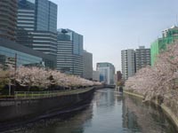
In watershed areas of Meguro River flowing through Tokyo, urbanization has been promoted since the Meiji Period, and the water quality was extremely deteriorated in the high-growth period. Then, bubbles of detergent floated on the water surface and unpleasant odors were produced over a long period. Later, the water quality and scenery were dramatically improved through the introduction of sewage systems and local citizens’ efforts.
However, there are many combined sewer systems in the watershed area of Meguro River even today, and there are some problems such as the river giving off a bad odor at times of flooding. Currently, various approaches aiming at water environment improvement such as releasing reclaimed sewage water and water purification experiments by using highly concentrated oxygen dissolution water are being conducted to restore the watershed areas where people can enjoy cherry-blossom viewing.
By JRRN-secre | category: Community and urban river restoration,Kanto | Comment(0) | Trackback(0) |
Date: 2012.01.05 16:13
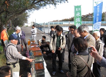
|
Movable aquarium by local citizen group
|
In the high-growth period, human sewage was fed into this river and the water quality was extremely deteriorated. In recent years, however, due to river improvement balancing flood control and environmental preservation with specific efforts for collaboration between citizens and administration in addition to improvement of the surrounding sewer network, the water quality and river environment has been improved greatly.
In the downstream area of Saitama Prefecture, this area is used as a water-attracting park because the bank protection work is small scale and the water-attracting qualities are high. In particular, in the downstream area in the north of Niiza City, many people enjoy fishing and the tranquil Musashino landscape is preserved as there is no residential area. In the upstream site of Higashikurume City, Tokyo, a cycling road has been built on either bank, where many people enjoy walking.
The Kurome River was awarded grand prix in the 5th “Iikawa & Iikawa-zukuri” workshop (old name: River’s day workshop in Japan) in Sep. 2012.
By JRRN-secre | category: Community and urban river restoration,Kanto | Comment(0) | Trackback(0) |
Date: 2012.01.05 16:12
The Kokubun and Hayato areas lying on each side of Amori River were targeted in the "Kokubun, Hayato Technopolis plan" in March 1984 and river improvement work such as invitation of advanced technology developing companies was promoted.
For Amori River, which is an important water/green axis in this Kokubun, Hayato Technopolis district, a "hometown river model project" (the current hometown river improvement project) was started in June 1988 with the catch phrase of "From the past to the future, Amori River, a river of meetings and relaxation," while the water control safety degree between unimproved zones was raised. By taking advantage of the historical features from the age of myth and rich nature, the waterfront space has been improved to become a good place to meet people.
By JRRN-secre | category: Community and urban river restoration,Kyushu | Comment(0) | Trackback(0) |
Date: 2011.09.10 19:00
Bachi River runs through the center of Kurosaki, flowing into Dokai Bay. In the past, people enjoyed fishing for crucian carps and children gathered and played at the waterfront. With the great flood damage in 1953 as a trigger, river improvement work to cast concrete in the three faces was conducted and the river became a drainage canal and was ignored by local residents.
Later, a river restoration project was started in 1995 and a research group was established to make best use of citizens' opinions. As a result of discussions with various parties concerned with the future of the river, the "Bachi River Renaissance Plan, Basic Concept" was drawn up.
Today, fireflies have returned to Bachi River and from 2006 on "Bachi River firefly festival" has been held. Bachi River won the "Handmade Hometown Award" in 2004.
By JRRN-secre | category: Community and urban river restoration,Kyushu | Comment(0) | Trackback(0) |
Date: 2011.09.10 18:59
Uzuma River was so contaminated that it was named the second-most contaminated river in Japan.
However, the clear stream was recovered through water quality improvement measures and the adoption of the Hometown River Model Project. Also a comfortable water environment and living climate has been regenerated, where transportation by ship has restarted and 100,000 carps swim. In this way, local regeneration rooted in history and culture has been realized.
Today, Uzuma River is evaluated as a tourist spot with the historical landscape of Tochigi city, designated as one of the 100 best city landscapes in Japan. It also won the "Public Color Award - 10 environmental colors" in 2003 and the grand prize of the "Handmade Hometown Award" in 2005.
By JRRN-secre | category: History and traditional restoration,Navigation restoration,Kanto | Comment(0) | Trackback(0) |
Date: 2011.09.10 18:46
Ushiroda River, which runs through the center of Miyazaki City, was used to carry a lot of human sewage as a result of the rapid urbanization and the water environment was so deteriorated that the water gave off a terrible smell.
Therefore, it was changed into a culvert as the Ushiroda main trunk line, on which a greenway park was constructed. Moreover, a babbling stream waterway was constructed in the greenway park by using the high-quality treated water from the sewage treatment plant under the "Aqua-park Model Project".
Today, children and adults are attracted to the clear stream like before containing fish and the green spaces for recreation that have been created.
Ushiroda River was selected as one of the 100 revived waters and won the "Handmade Hometown Award" in 1988 and 2007 as well as the "City Landscape Award" in 1993.
By JRRN-secre | category: History and traditional restoration,Kyushu | Comment(0) | Trackback(0) |
Date: 2011.09.10 18:41
Aiba River is a 2.6km-long, 4m-wide small river, flowing east and west in the old samurai residential area in Hiyako, Emukai and Kawashima districts with the reminiscent atmosphere of a castle town. In the past there were indigo-dye shops operated by the clan on the riversides and the water was deep blue all over the river, thus this river was called Aiba (indigo-dye shop) River.
This river was used originally for supplying water for agriculture and daily living. In the middle of the Edo Period, the river was excavated so that ships could pass to transport firewood and coal.
Today, the water is still used for irrigation, disaster-prevention and daily living and the landscape and environment is conserved under a public-private partnership. As a canal, it is indispensable for civil life as a tourist spot of Hagi City, a castle town. It was designated as one of the best 100 canals in Japan and it won the "Handmade Hometown Award2 in 1988.
By JRRN-secre | category: Community and urban river restoration,History and traditional restoration,Chugoku | Comment(0) | Trackback(0) |
Date: 2011.09.10 18:38
Tsuwano Town called "a small Kyoto of Sanin" is famous for its beautiful streets and the carps living in Tsuwano River running through the center of the town. It has been famous as a district that produces high-quality water since olden days and sake breweries using the spring water stand in a row in the town.
In landscaping the town, iris-planted waterways were laid in many places and many houses keep carps by using the water. Just as in olden days, residents pump water from the waterway for domestic use even today.
Tsuwano waterways were awarded the "Civil Engineering Design Prize 2002, JSCE (Japan Society of Civil Engineers)" and a City Landscape Award in 2006.
By JRRN-secre | category: History and traditional restoration,Chugoku | Comment(0) | Trackback(0) |
Date: 2011.09.10 18:34
For Genbee River, citizens, companies and the government are working together on Genbee River Waterpark Project, by cleaning the environmental water and improving the recreational waterfront to recover the deteriorated waterfront environment. Citizens' groups clean the river periodically and release nymphs of fireflies into the river. As a result of these activities, a beautiful waterfront richly endowed with nature has been recovered.
Today, Genbee River is highly evaluated as a good case example in which a lost river has been recovered by citizens participating in urban development. It won the highest award of the "Civil Engineering Design Prize 2004, JSCE (Japan Society of Civil Engineers)" and “the Handmade Hometown Award" (local improvement section), City Landscape Award, "the Beautiful Town Award" in 2005 and the gold prize of "the Excellent Tourist Spot Creation Award” in 2006. Also it was designated as one of the 100 famous Heisei waters, 100 hometowns for nurturing water, greenery and culture and 100 best canals in Japan.
By JRRN-secre | category: Community and urban river restoration,History and traditional restoration,Chubu | Comment(0) | Trackback(0) |
Date: 2011.09.10 18:33
Tamagawa Waterworks is a canal approx. 43km in length from Hamura City, Tokyo to Yotsuyaokido, Shinjuku Ward, excavated by the government of Edo to relieve water shortages in Edo by taking water from Hamura Diversion Weir of Tama River. Today, the part from Hamura Diversion Weir to Kodaira Observation Point approximately 12km in length is actually used.
Tamagawa Waterworks is a long wooden structure built based on the excellent surveying technology of early modern ages. It was designated as one of the Japanese historical places in August 2003 because it is a valuable civil engineering heritage as the water supplying facilities for a large city of Edo and irrigation water for Musashino highland in modern times.
By JRRN-secre | category: History and traditional restoration,Kanto | Comment(0) | Trackback(0) |
Date: 2011.09.10 18:32
Rokugo and Shichigo moats are important agricultural waterways that supply water from Hirose River of Natori River system to the rural area in the east of Sendai City. These waterways were excavated and opened in the Edo Period and used as the moat of Wakabayashi Castle, which was where Masamune Date lived in his final years. They were important artery waterways for supplying water for agriculture, disaster-prevention and daily living. However, due to the advancement of urbanization, they were changed into culverts in some parts and the water environment was extremely deteriorated by dumped-waste and human sewage inflow.
To improve the waterfront spaces and water environment, a "non-irrigation period flow examination" to flow as much water as possible even in the non-irrigation season was started by Sendai City mainly in 1999. This approach was institutionalized in the river law in March 2006 as "environmental flow" aiming at improving the local water environment. Shichigo moat was designated as one of the best 100 canals in Japan.
By JRRN-secre | category: History and traditional restoration,Tohoku | Comment(0) | Trackback(0) |
Date: 2011.09.10 18:30
When Hidetsugu Toyotomi opened a castle town at the base of Mt. Hachiman, the "Hachiman Moat" running through Omihachiman City was built as a canal to allow barges running in Biwa Lake, which was the artery at the time, call into Hachiman.
Due to the rapid urban development after the war, the water environment of Hachiman River was deteriorated and in the decade starting in 1965, a land reclamation plan was embodied. However, activities toward dredging and regeneration of the moat were started mainly by citizen groups who considered the moat to be historical heritage from their ancestors. Such activities are continued even today to maintain the landscape of the moat and improve the water quality by the "Citizens' Association to Protect Hachiman Moat."
Although transportation by ship has ended, ships are still used by tourists in imitation of the traditional elegant boating of the Imperial Court. Today this has become a special feature of sightseeing tours and 280,000 people visit this area yearly. Hachiman River was designated as one of the best 100 revived waters in Japan.
By JRRN-secre | category: History and traditional restoration,Navigation restoration,Kinki | Comment(0) | Trackback(0) |
Date: 2011.09.10 18:29
Since the beginning of the Edo Period, ships have sailed Shingasi River transporting people and goods and it also served the cultural role of connecting Kawagoe and Edo closely. However, such a role was weakened along with the opening of the railways. Also the volume of the river water became insufficient due to river improvement work for flood prevention. Thus, transportation by ship was discontinued in the beginning of the Showa Period.
Today, there is an attempt to revive transportation by ship on Shingasi River to promote tourism, and a social experiment of transportation by ship for tourists is being conducted in the water area near streets with the atmosphere of Edo in central Kawagoe City.
By JRRN-secre | category: Navigation restoration,Kanto | Comment(0) | Trackback(0) |
Date: 2011.09.10 18:28
Itako City, together with Sahara City located in the south of Tone River, flourished as a transshipping port to convey products of each clan of Oshu to Edo.
Today we can enjoy attractive scenery unique to a "riverside district" as a tourist town typified by small ships coming and going on the water and boatwomen.
Itako boating station with a 2,000m course using the straight river area is highly evaluated as a waterfront for social interaction. It won the "Handmade Hometown Award" in 1986.
By JRRN-secre | category: Navigation restoration,Kanto | Comment(0) | Trackback(0) |
Date: 2011.09.10 18:27
Nishitakase River running through Kyoto City was opened as a canal for transportation by water. Later, it was used to discharge the water for textile dyeing such as Kyo Yuzen printing and the color of the river water changed daily and the water quality deterioration was serious.
Under the circumstances, the contamination was reduced and ozone treatment facilities were installed in 1997.Since then the color of the river and foam formation have been improved dramatically and the water environment of this river has greatly recovered. In addition, this river was selected as a "Limpid Stream Renaissance II project river" and because efforts were made to create an environment for water amenities and improve the water quality, a river environment suitable for a stroll in Kyoto has been recovered.
By JRRN-secre | category: Water quality Restoration,Kinki | Comment(0) | Trackback(0) |
Date: 2011.09.10 18:23
For Ayase River, which was recorded as the worst river in terms of water quality for 15 consecutive years, a project was conducted to channel the water of Ara River upstream as part of "Limpid Stream Renaissance II" (a water environment improvement emergency action plan). This project won the Japan Society of Civil Engineers' Environmental Award in 2001 as Japan's first project using the tunnel upper part for subways and the lower part for a river water conduit.
By JRRN-secre | category: Water quality Restoration,Kanto | Comment(0) | Trackback(0) |
Date: 2011.09.10 18:18
Furo River, running through Saitama Prefecture, was once called "Toshitorazu (meaning unaging) River" because the main water source was a spring that dried up in winter and the flowing water did not see the old year out.. However, a large quantity of living drainage was discharged into the river due to the population increase in the basin and the river was named the most contaminated river in Japan and such a disgraceful situation was continued in the past..
Now, the"basin sewage project for Furo River water quality environment conservation measures" are being conducted to recover the water environment by resolving the sewage-treated water into Furo River. Moreover, efforts are being made to conserve and regenerate the water environment through water environment improvement projects such as "Limpid Stream Renaissance 21" and "Limpid Stream Renaissance II".
By JRRN-secre | category: Water quality Restoration,Kanto | Comment(0) | Trackback(0) |
Date: 2011.09.10 18:16
Concerning Yanase River, a tributary stream of Shingashi River, running through Saitama Prefecture, the water quality was extremely deteriorated in the decade starting in 1975 because of the rapid increase of the population during the high-growth period. However, the water quality has been improved gradually as a result of the construction of a sewage system. In 2006, a river environment improvement project was started based on the “Yanase River basin water circulation master plan”. To solve water problems related to river conservation, water utilization and the water environment, river restoration activities are being conducted under cross-sectional cooperation of not only the river administrator but also the administrative agencies concerned.
By JRRN-secre | category: Water quality Restoration,Kanto | Comment(0) | Trackback(0) |
Date: 2011.09.10 18:15
In Komaki River, the water quality was deteriorated by urbanization and the river was named the "dirtiest river in Yamagata Prefecture" each year from 1996 to 1999. People in this area suffered from the serious deterioration of the water environment.
Under the circumstances, local residents voluntarily established "a group to clean up the Komaki River of Sakata City" and are conducting purification activities earnestly. As an approach to utilize the existing agricultural water and the agricultural facilities to improve the waterfront environment, a project to flow the purified water (ambient water) from Mogami River to Komaki River by changing the place where agricultural water is discharged started in 2007 for the first time in Japan. Thus the water quality has been improved.
By JRRN-secre | category: Water quality Restoration,Tohoku | Comment(0) | Trackback(0) |
Date: 2011.09.10 18:14
In the "Azami-no-se" area of Matsuura River running through Matsuura County of Saga Prefecture, people have long suffered from flood damage. Therefore the retarding method has been adopted as the flood countermeasure instead of building embankments in this region and resident-participation projects to recover organisms in the valuable river environment and regenerate the contact between people and organisms are being promoted. As a result, a traditional fishing method has been revived and children have begun to play by the riverside again. In this way, the connection between people and nature has been regenerated.
By JRRN-secre | category: Nature oriented restoration,Community and urban river restoration,Kyushu | Comment(0) | Trackback(0) |
Date: 2011.09.10 18:12
Shinji Lake is located in the eastern area of Shimane Prefecture. It is a typical brackish lake in Japan together with Nakaumi. Its rich nature and excellent landscape are used for fishery, sightseeing and recreation.
However, the conditions surrounding the water environment are severe due to socioeconomic activities and the changes in lifestyle in the peripheral basin, thus water quality conservation is an important issue to be solved.
Under the circumstances, a “lake water quality conservation plan” to conserve the water quality has been drawn up and various water quality improvement programs are being conducted. In addition, activities to plant and grow reeds have been promoted by industry - government - academia - private collaboration including local elementary school students and the pollution load in the basin is steadily decreasing.
By JRRN-secre | category: Bay and lake restoration,Chugoku | Comment(0) | Trackback(0) |
Date: 2011.09.10 18:11
In Yodo River running through Osaka, earth and sand are deposited around the spur dike, which was built to maintain the course for cargo ships, and many pools and valuable habitats for organisms have been created. However, because the water level fluctuation has decreased as a result of the construction of Yodo River Great Weir downstream, its environmental impact on Johoku pools is a concern.
For this reason, an experiment toward the recovery of the pool environment is being conducted by improving the operation of the weir to increase the water level fluctuation and improve the in-pool water quality.
By JRRN-secre | category: Nature oriented restoration,Navigation restoration,Kinki | Comment(0) | Trackback(0) |
Date: 2011.09.10 18:09
At the mouth of Shonai River and Shin River, Fujimae mud flats spread, which is well known for visiting natatorial birds. Downstream of Shonai River, sand deposition is accelerated on the riverside, causing a floristic variation from reeds to miscanthus sacchariflorus and willow tree communities in the riverbed. At the same time, poor waterfront vegetation caused by decreasing flood frequency has become a problem in the areas used for agriculture and as a playground.
Under the circumstances, a project is being conducted to regenerate the waterfront vegetation such as the reed beds by excavating the riverbed to reduce the waterfront gradient and recover the frequency of floods in the riverbed following the heavy rain in Tokai in 2000.
By JRRN-secre | category: Nature oriented restoration,Chubu | Comment(0) | Trackback(0) |
Date: 2011.09.10 18:07
In midstream Chikuma River in Nagano Prefecture, most of the banks and side bars were pebble riverbeds until the Meiji Period. These days, however, the vegetation grows thickly in many places while waterfront plants such as reeds and cattails are disappearing rapidly. This is because the channel has become static as the riverbed has lowered and the frequency of flooding reduced.
For this reason, a natural regeneration project research was started in 2002 to regenerate the diversified functions of the river. In Awasa district of Chikuma City, a trial excavation experiment is being conducted to study the shape of the channel to be excavated as well as the excavation method so that a river environment unique to Chikuma River may be regenerated.
By JRRN-secre | category: Nature oriented restoration,Chubu | Comment(0) | Trackback(0) |
Date: 2011.09.10 18:06
In the area of Kita River running through Fukui Prefecture, great damage was caused over large areas by the season’s 19th typhoon in 1997. With this disaster as a trigger, Japan’s first special emergency project for countermeasures against serious river disasters was adopted and drastic river improvement work has been conducted since then.
To conduct this emergency project, the “Kita River Rehabilitation Exploratory Committee” consisting of experts, local representatives and organizations concerned was established and measures are being taken to secure the continuity of the riffles and pools and properly cut and conserve trees by generating a natural waterside.
In 1994, these efforts were designated as “a model project to promote the creation of a river up which fish can easily swim”. From the viewpoint of securing the vertical continuity of the river, a project to regenerate the habitat for aquatic life is being conducted by creating riffles and pools by utilizing the sediment movement by natural power rather than by artificially digging the riverbed.
By JRRN-secre | category: Nature oriented restoration,Kinki | Comment(0) | Trackback(0) |
Date: 2011.09.10 18:05
Downstream of Ara River, wetland existed in the decade starting in 1955, but it has mostly been lost as a result of promotion of flood channel construction and low water bank protection improvement.
Therefore, efforts are being made to not only conserve the existing natural areas but also create new natural areas and establish a natural area network for the purpose of conservation of the reedy fields, conservation and regeneration of the muddy flats and regeneration of the wetland on the flood channel.
Today, a muddy flat regeneration test is being conducted in Komatsugawa district and a natural restoration plan based on new knowledge including bank protection improvement and a wave-absorbing facility installation is being researched.
By JRRN-secre | category: Nature oriented restoration,Kanto | Comment(0) | Trackback(0) |
Date: 2011.09.10 18:02
The Arakawataroemon district lying astride Okegawa City, Ageo City and Kawajima Town is one of the districts having the former Ara River channel, where a rich natural environment merged with the ambient surroundings of the wetland and lakeside forests was formed. Today, however, the decrease in the flood frequency due to the lowering of the riverbed of the main stream of Ara River and the drying of the river by sediment deposition in the former channel are advancing and the existence of this good ecological environment is threatened.
For this reason, a natural restoration conference for the former Ara River channel was established as the first project according to the Law for the Promotion of Nature Restoration in Japan in 2003 and nature restoration programs have been conducted as an important base of Ara River ecological network.
By JRRN-secre | category: Nature oriented restoration,Kanto | Comment(0) | Trackback(0) |
Date: 2011.09.10 18:00
The lakeside area behind Kasumigaura Bay used to have a diverse natural environment including wetlands and vegetation zones. Today, however, the natural environment around the lakeside and the biodiversity of the inhabitants have been greatly damaged.
In particular, because the population of nymphoides peltata, an endangered plant species, has rapidly diminished, urgent maintenance measures for the Kasumigaura lakeside vegetation zone have been taken to conserve and regenerate the vegetation zone in cooperation with NGO organizations closely connected with the local communities since 1996.
Also, a natural restoration project is being conducted in the Tamura, Okijuku and Tozaki districts located on the middle lakeside of Kasumigaura (Nishiura) to conserve and regenerate the lakeside zone that forms a connection point between the back hill and the lake, where a huge variety of animals and plants can grow and live.
By JRRN-secre | category: Bay and lake restoration,Kanto | Comment(0) | Trackback(0) |
Date: 2011.09.10 17:57
As for Aka River running through Yamagata Prefecture and flowing into the Japan Sea, the number of migratory fish including oncorhynchus masou has decreased which is caused by migration prevention due to the groundsill and the disappearance of deep pools, which provide a valuable habitat. Along with the thick growth of trees such as Robinia pseudoacacia, the bar area is decreasing and the riparian part shrinking, thus the river landscape unique to Aka River has been lost.
For this reason, a nature regeneration project including the improvement of fish passes and Robinia pseudoacacia extermination tests is being conducted to secure the continuity of the river, conserve and create the river environment and regenerate the original nature of Aka River.
By JRRN-secre | category: Nature oriented restoration,Tohoku | Comment(0) | Trackback(0) |
Date: 2011.09.10 17:56
Ishikari Plain has been changed to a vast agricultural land by embankment works and the agricultural land development conducted since the Meiji Period. As a result, the wetland spread in the low-lying area of the basin and the forests along the river were lost, the shape of the river was simplified and the ecological environment was dramatically deteriorated.
In order to regenerate the lost river environment of Ishikari River, pools are being constructed (which are or will be connected to the main stream when the water level increases) to diversify the river, restore the wetland environment and regenerate the forest environment at the meeting point between Ishikari River and Tobetsu River, a tributary river.
By JRRN-secre | category: Nature oriented restoration,Hokkaido | Comment(0) | Trackback(0) |
Date: 2011.09.10 17:52
Yanagawa’s canals were once devastated. The citizens participated in the movement to improve environment, ahead of other cities. Their driving force was that, during the over 100 meetings with the government, each member recalled the “life with the canals,” the days people enjoyed fishing and playing in the water.
With the understanding and cooperation by the citizens, dredging was unexpectedly well proceeded in a short period, together with the citizens. It resulted in a dramatic decline of mosquitoes, in changing previously flood prone areas to flood-free, and in a rise of citizens’ morale for river protection. Especially, the ex-moat sections in the central target areas, where coastal planted landscaping and walking trails were constructed, are now organically utilized as the relaxation place for the local people, and have many tourists, contributing to the Yanagawa City’s economy.
>>More details (PDF 79KB)
By JRRN-secre | category: History and traditional restoration,Kyushu | Comment(0) | Trackback(0) |
Date: 2011.03.31 18:16
Tsurumi River basin was quite activated from the late 1960s with rapid city development, but it also came to have various problems such as flood control, environment, and disaster prevention. Given the situation that flood control safety level was hard to maintain, a committee of academic experts, basin local government, and river administrator was set to find a basin-wide solution for integration of river development and flood control measures. This is a pioneer of total flood control efforts in Japan. Beyond the basin measures such as rain runoff control, the local government’s urbanization plan and development projects were involved.
>>More details (PDF 54KB)
By JRRN-secre | category: Community and urban river restoration,Kanto | Comment(0) | Trackback(0) |
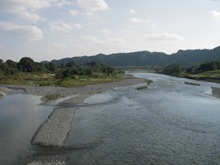
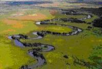
Date: 2011.03.31 18:15
Shibetsu River has experienced constructions to straighten its winding stream to lower its underground water level, aiming at preventing flood and at better drainage of the basin, which was originally a peat district. Changes of the times have changed Shibetsu River’s requirements. With the local people’s voice asking for a better environment, Hokkaido Regional Development Bureau is working on a nature-restoring river development plan, aiming at restoring the nature-abundant original river conditions. In order to research the effect of straightened streams, the winding streams are partially restored as an experiment.
>>More details (PDF 51KB)
By JRRN-secre | category: Nature oriented restoration,Hokkaido | Comment(0) | Trackback(0) |
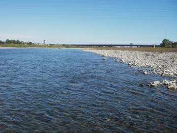
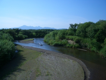
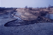
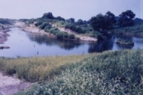
Date: 2011.03.31 18:13
Kushiro River
(source: RFC)
|
The natural wetland environment of Kushiro River, which is a registered wetland designated under the Ramsar Convention in 1980, has deteriorated because of the land development in the surrounding area, the increased amount of sediment flowing into the wetland caused by the straightening of the inflow rivers and the lowering of the water table.
The "Kushiro Wetland Natural Environment Regeneration Project," is being conducted mainly by the Ministry of Land, Infrastructure, Transport and Tourism and Ministry of the Environment to rehabilitate and conserve the wetland by restoring the meandering streams to their original state and controlling the wetland vegetation.
>>More details (PDF39KB)
By JRRN-secre | category: Nature oriented restoration,Hokkaido | Comment(0) | Trackback(0) |
Date: 2011.03.31 18:11
Before
(source: RFC)
|
|
After
(source: RFC)
|
In 1982, Yokohama City began developing shallow water channels along the Itachi River in order to restore the waterfront to its natural state. Prior to this, mudflats had developed as a result of earlier river improvement construction projects.
There were several goals to this river Restoration plan: to maintain sufficient water depth (i.e. to restore the water depth to pre-construction levels),to restore waterfront vegetation, to revive the riverbed microtopography in both rapid and slow streams, and to develop the river-walk. Through experimentation with various construction methods, the waterfront environment has now regained its natural vitality and once again attracts the local people.
>>More details (PDF 48KB)
By JRRN-secre | category: Community and urban river restoration,Kanto | Comment(0) | Trackback(0) |
Date: 2011.03.31 18:10
In Dokai Bay, located in the northwest part of Kitakyushu City, harmful substances discharged by concentrated heavy chemical factories accumulated. It was once called "a dead sea".
However, as a result of dredging of Dokai Bay through citizens' movements by women's associations and activities by Kitakyushu district labor unions, it has been regenerated as a treasure trove of fishery products. Although there are still some heavy chemical factories in the coastal area, the water quality has been dramatically improved and it is planned to construct Dokai Bio Park and Dohoku and Okudoukai green spaces. In this way, an environment where many wild birds and animals and plants can live is being regenerated.
>>More details (PDF 46KB)
By JRRN-secre | category: Bay and lake restoration,Kyushu | Comment(0) | Trackback(0) |
Date: 2011.03.31 18:09
"Megane Bridge" over Nakashima River is the oldest arch-shaped bridge in Japan, designated as a national important culture asset. It is one of the main sightseeing spots of Nagasaki City and many tourists visit there.
In Nakashima River Water Control Plan, it was required to remove the bridge in order to widen the river channel. Based on the citizens’ opinions and as a result of an experiment with a model, however, it was determined to conserve the bridge at the present location by constructing a bypass waterway on either side to flow down flood water safely. Today the area around the bridge has been improved as Nakashima River Park, which is a place of recreation and relaxation.
By JRRN-secre | category: History and traditional restoration,Kyushu | Comment(0) | Trackback(0) |
Date: 2010.09.10 18:49
Ishii Flume was constructed to secure the household water supply in Saga castle town and the agricultural water supply in Saga Plain in the Edo Period approximately 400 years ago, when people frequently suffered from droughts and water supply stoppages.
Over a period of approximately 350 years from that time until 1960 when Kawakami head works were constructed upstream, it had been used as a water utilization facility. In 1963 it was damaged by a great flood.
Later, a historical waterfront improvement project was started in Ishii Flume area through collaboration between Saga Prefecture, Saga City, Yamato Town and Ministry of Land, Infrastructure, Transport and Tourism.
Today, activities are being conducted under the theme of "the water flow of the homeland toward tomorrow again" to hand the important river civil engineering technology on to future generations, learn the history of Saga's water and land development and create an local community base where people can enjoy Kase River waterfront environment with rich nature by conserving, regenerating and utilizing Ishii Flume, a valuable cultural heritage.
By JRRN-secre | category: History and traditional restoration,Kyushu | Comment(0) | Trackback(0) |
Date: 2010.09.10 18:47
Yanta River is a class A river flowing from the mountainous area of Saigo Village of Fukushima Prefecture and joining Abukuma River. It runs east and west through the south part of Shirakawa City.
Since it was designated as a target river of the homeland river restoration project, efforts have been made for the river restoration for water control and environmental improvement around the river from the viewpoint of urban development.
Yanta River was largely damaged by concentrated heavy rain in August 1998. After that a "special emergency project against serious river disasters" was carried out. As a result of the promotion of a river restoration project called "the homeland river restoration project" under the theme of "The Yanta River, a clean stream with history and atmosphere", the local community has been vitalized and the natural environment conserved.
By JRRN-secre | category: History and traditional restoration,Tohoku | Comment(0) | Trackback(0) |
Date: 2010.09.10 18:43
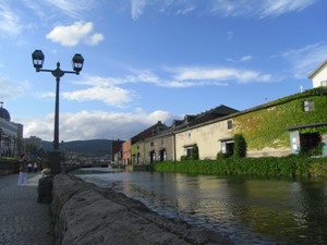
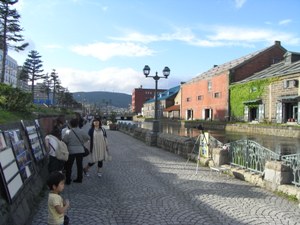
|
Current condition(Photo by Michiya Tannai, Aug. 2009)
|
Otaru Canal was completed in 1923 as a port facility. As it was constructed by reclaiming offshore other than by digging inland, it is characterized by a gently-curved shape in a fan-like form other than a straight-line shape. It played the important role of loading and unloading cargoes between ships berthed in the port and warehouses. However, in postwar days, the mission was ended because the pier of the port was constructed.
In 1986, after the controversy as to whether to reclaim it or not over ten-odd years, part of it was reclaimed, half of the canal in width was changed into a road and walkways and parks were constructed. In this way Otaru Canal was regenerated into the present form. In the walkways, 63 gas lamps were built and the stone warehouses along the canal were conserved as they were. At nightfall gas lamps are lit and the stone warehouses are lit up and an atmosphere different from that in the daytime can be seen.
By JRRN-secre | category: History and traditional restoration,Hokkaido | Comment(0) | Trackback(0) |
Date: 2010.09.10 18:42
Shimabara City, which is likened to a small Kyoto surrounded by rich nature of the sea and the mountains, was called "a lagoon city" from old times because water cultivated by the Unzen mountain chain sprang out in many places in the city. However, Shimabara was greatly damaged by the eruption of Mount Unzen-Fugen. Since then, the reconstruction of the city has been promoted by attaching weight to "water".
Urban development under the theme of "water" was started and pocket parks, public drinking fountains, ponds, objet d'art, etc. have been constructed. Today, efforts are made to secure good landscapes and pleasant and comfortable pedestrian traffic lines and form attractive urban centers to collect visitors by improving the facilities using springs seen in various locations in the city through the Shimabara City spring network improvement project.
Shimabara Spring won the "Handmade Homeland Award" and was selected as one of the 100 water hometowns and 100 famous waters.
By JRRN-secre | category: History and traditional restoration,Kyushu | Comment(0) | Trackback(0) |
Date: 2010.09.10 18:39
Nishikawa Channel and its tributary Edagawa Channel take the water from Asahi River as the Asahi River joint canal, running southward through the center of Okayama City. They provide irrigation water for the paddy field spread in the south of the city. On either side of these canals, a water amenity park containing walkways, summerhouses, corridors over the waterway, etc. was constructed. It is popular among citizens as an esplanade.
In the Nishikawaryokudo, people enjoy the firefly canal created by dividing the water, a wind-up doll using a waterwheel, a cascade and a terrace over the water. In the Edagawaryokudo, a calm space is provided, where stones produced in Okayama Prefecture are positioned in a Japanese garden style.
Nishikawa Canal was designated as one of the best 100 canals in Japan.
By JRRN-secre | category: History and traditional restoration,Chugoku | Comment(0) | Trackback(0) |
Date: 2010.09.10 18:36
Kuratsuki Channel is a waterway 1,500 m in total length running from the center of Kanazawa City, Ishikawa Prefecture to the northwest area. In ancient times, it was used for irrigation and fire prevention for the castle and as the motive energy of the waterwheel to squeeze canola oil. Even today the rural area extending from the center of Kanazawa City to the northwest part is irrigated by this canal. In the urban area, it is used as water for fire prevention and for agriculture downstream.
In 1993, the channel was partially opened and a pocket park was constructed in the neighborhood of Kakinokibatake and in 1999 it was opened in the district between Korinbo and Takaoka Town. This helped to create a pleasant and lively atmosphere in the central urban area. Kuratsuki Channel was designated as one of the 100 best canals in Japan.
By JRRN-secre | category: History and traditional restoration,Hokuriku | Comment(0) | Trackback(0) |
Date: 2010.09.10 18:32
Ibo River in Hyogo Prefecture flowing into Seto Inland Sea had a poor record: it was designated as the 3rd- to 5th-worst river in Japan in terms of water quality because the wastewater was discharged from households and the local industries such as leather product makers.
Under the circumstances, construction of a sewage system was promoted in the Ibo River Basin and the sewage system penetration rate was improved. In addition, the whole quantity of the leather makers' wastewater has been accepted by the water treatment facilities since 1994. As a result, Ibo River made rapid progress in recovery and gained the 2nd-best place in water quality in the Kinki region in the following year. It was also designated as one of the "100 revived waters". Today, the ascent of natural plecoglossus altivelis was observed for the first time in 40 years and the recovery of a clean stream of Ibo River was welcomed by local people. A fishing contest and river-rafting held by a local group is becoming popular year by year and the connection between the local community and the river has been revived.
By JRRN-secre | category: Water quality Restoration,Kinki | Comment(0) | Trackback(0) |
Date: 2010.09.10 18:24
Sana River running through the eastern Mikawa area of Aichi Prefecture became so contaminated that the BOD was 60 mg/l, which was measured at the environmental basing point located downstream in 1978. This was because of the urbanization in the peripheral area that occurred during the decade starting in 1965. However, the construction of the sewage system was started in Toyo River Basin including Sana River Basin in 1980 and since then the water quality has been largely improved along with the progress of the sewage system improvement.
Today, children playing with water can be seen and a project to change the dike into a flower corridor is being promoted by community residents. Also, this river has been selected as one of the "100 revived waters", thus it is being changed into a river cherished by the local people.
By JRRN-secre | category: Water quality Restoration,Chubu | Comment(0) | Trackback(0) |
Date: 2010.09.10 18:22
In Fushimi and Takahashi Rivers running in the southern part of Kanazawa City, a serious problem of water quality deterioration was caused by the rapid urbanization of the surrounding areas. The water quality was such that the BOD exceeded 10 mg/l but it was improved to approximately 3 mg/l by the construction of a sewage system that started in 1976.
Today, the ascent of salmon is seen and the former clear stream has been revived. The "river festival" is held by the local people and the river space has become a place for recreation and relaxation for citizens.
Fushimi and Takahashi Rivers were recognized as rivers in which the water environment was conserved and recovered by the sewage system and designated as one the "100 revived waters."
By JRRN-secre | category: Water quality Restoration,Hokuriku | Comment(0) | Trackback(0) |
Date: 2010.09.10 18:20
In the mouth of Fushino River running through Yamaguchi City, a vast tidal flat spreads, which is one of the greatest tidal flats in the West Setouchi region. It attracts migrant birds and it was selected as one of the 500 important wetlands in Japan.
However, due to the floating mud flowing in from the middle and upstream basins and the delay in taking domestic sewage countermeasures, oystershells were built up, the muddy tidal flat area was expanded and the biomass of fish, crabs and wild birds was decreased. To address this problem of the tidal flat ecosystem alteration a “framework to create a rich basin of Yamaguchi (Fushino River model)” was drawn up through collaboration between industry, educational institutions and the administration in March 2003. Today, the organizations concerned are cooperating to regenerate the tidal flats and create Zostera beds on a trial basis and wild bird research and beach cleaning is being performed.
By JRRN-secre | category: Nature oriented restoration,Bay and lake restoration,Chugoku | Comment(0) | Trackback(0) |
Date: 2010.09.10 18:12
In Maruyama River Basin, the natural habitat was changed by agricultural land improvement, forest development and housing land development. In particular, ciconia boyciana have vanished in this area since 1971.
Today, ciconia boyciana (whose wild species are now extinct in Japan) is bred artificially in the prefectural “Ciconia boyciana Home Park” located in Toyooka City for release into the wild. As part of the environmental improvement measures to allow ciconia boyciana and various living organisms as a food source for ciconia boyciana, a river and waterfront environmental regeneration project is also being conducted.
By JRRN-secre | category: Nature oriented restoration,Kinki | Comment(0) | Trackback(0) |
Date: 2010.09.10 18:10
Inland lakes have diversified functions represented by natural ecosystem maintenance and water quality improvement. Hayazaki Inland Lake, which contacts Biwa Lake, was once the largest spawning ground of endemic carassius cuvieri in Biwa Lake, where precious plants including vallisneria natans and brambles were grown and aquatic birds such as tachybaptus ruficollis and resident birds lived. However, the area has been shrunk by agricultural land reclamation. Also the disappearing waterfront ecotone due to the construction of the dike on the lakeside is affecting the growth of various indigenous organisms.
For this reason, Hayazaki Inland Lake Restoration Project was inaugurated as a leading-edge project to conserve the Biwa Lake ecosystem. Since 2001, regeneration of the inland lake by flooding an area of 17 ha out of the 89 ha reclaimed agricultural land has been studied.
By JRRN-secre | category: Bay and lake restoration,Kinki | Comment(0) | Trackback(0) |
Date: 2010.09.10 18:08
In the middle basin of Shinano River, problems such as the simplified river channel, vanishing shallows and pools, change of high water channels into the land area and overgrowth of alien species such as robinia pseudoacacia have occurred because river improvement work focusing on flood control was promoted.
Now, however, a natural regeneration project is being conducted to restore the waterfront line (ecotone) and pools and recover the former channels. Also since July 2001, efforts have been made to increase the outflow from Nishiotaki Dam on a trial basis in cooperation with power generation companies. This is because the shallows are discontinued and algae proliferated abnormally due to a decrease in the river flow, which is caused by water intake for power generation and smoothing. While reviewing the effect and impact of an increase of the outflow on the downstream river environmental regeneration, we are improving the water environment adaptively and gradually.
By JRRN-secre | category: Nature oriented restoration,Hokuriku | Comment(0) | Trackback(0) |
Date: 2010.09.10 18:04
In the peripheral area of No River flowing through Tokyo, a diversified environment consisting of springs, forests, wetlands and vegetation zones spread in the past. Today, however, the diversified natural environment has been damaged by the urbanization along the river and change of land use.
Nevertheless, a project is being conducted to regenerate the wetlands by using springs, create habitats or growing spaces for various organisms and provide a place for environmental education where people can commune with nature around No River Balancing Reservoir, which was constructed to prevent flooding.
By JRRN-secre | category: Nature oriented restoration,Community and urban river restoration,Kanto | Comment(0) | Trackback(0) |
Date: 2010.09.10 18:03
Concerning Sanban Shallows spreading off the coast of Funabashi and Ichikawa Cities of Chiba Prefecture in the inner part of Tokyo Bay, problems such as a decrease of the brackish environment, a decrease of the marine area and an increase of the shallow sea area by lowering of the ground elevation occurred because the connection between Sanban Shallows and the rivers flowing in was weakened as a result of the postwar large-scaled land reclamation and the urbanization of the backland.
For this reason, Sanban Shallows restoration plan meeting (round-table conference) was established and many residents participated in it to regenerate the nature of Sanban Shallows. Efforts are being made to restore the tidal flats that once existed, secure the biotic diversity, provide rich and stable fishing grounds with an advanced water purification function to nurture tapes philippinarum, flounder, sea weeds, etc. and create a stopping point for aquatic birds and waterfront spaces where people can commune with nature.
By JRRN-secre | category: Bay and lake restoration,Kanto | Comment(0) | Trackback(0) |
Date: 2010.09.10 18:01
The river bed of Kinu River has been lowered largely due to a decrease of sediment supply and gravel quarrying. As a result, problems such as immobilized gut for ships, single-row-shaped shoals, a decrease of the flood frequency in the riverside, invasion and overgrowth of alien species such as eragrostis curvula occur and the original pebble riverside is being lost.
As it is important to conserve and regenerate the plants that grow on the pebble riverside such as aster kantoensis (one of the endangered species) in particular, a natural regeneration project is being conducted to restore the pebble riverside and the natural environment with aster kantoensis and create an environment where native riverside organisms can live and grow sustainably.
By JRRN-secre | category: Nature oriented restoration,Community and urban river restoration,Kanto | Comment(0) | Trackback(0) |
Date: 2010.09.10 17:58
In Sarobetsu Plain registered under the Ramsar Convention in 2005, the land becomes dry progressively due to the agricultural land improvement for developing dairy and arid plants such as sasa veitchii are increasing in number. The lowering water level of the marsh caused by a drainage project for bogs along with the agricultural land development is another problem.
Under the circumstances, the Sarobetsu natural regeneration project toward “coexistence of marsh and agriculture” is being conducted to recover the drying marsh and conserve the marsh by providing buffer zones in the agricultural land.
By JRRN-secre | category: Nature oriented restoration,Hokkaido | Comment(0) | Trackback(0) |
Date: 2010.09.10 17:55
Utonai Lake located near the confluence of Bibi River and Yufutsu River was registered under the Ramsar Convention in 1991. On the periphery of the lake, a rich natural environment including wildernesses and wetlands has formed. It is also a treasury of animals and plants and a wild paradise to which migrant birds such as swans arrive in flocks.
However, the valuable natural environment and the ecosystem is vanishing due to the land development around the basin, causing a reduction of the volume of the spring in Bibi River, dryness of the marginal environment, outflow of soil, water quality deterioration, a decrease of the wetland area, vegetation change, etc.
Today, a natural regeneration project is being conducted to restore the state of Bibi River and Utonai Lake seen in the 1960s and 70s based on four pillars: recovery of the volume of the spring in Bibi River, improvement of the spring quality, recovery of the current speed and river channel and recovery of the wetland environment around Utonai Lake.
By JRRN-secre | category: Nature oriented restoration,Bay and lake restoration,Hokkaido | Comment(0) | Trackback(0) |
Date: 2010.09.10 17:53
|
Before restoration
|
|
After restoration
|
Urbanization of Ara River basin gradually damaged its natural environment. Most areas of the plain with relatively conserved nature were riverbeds. Ara River biotope, 57 km away from the river mouth, is the midstream of the Ara River main stream. Hawks and foxes disappeared as the environment became worse. Given the situation, the wheat fields and meadows in the flat riverbeds have been improved to secure a large-scaled nature, good as the natural habitat, in combination with the neighboring Kitamoto nature watching park. Along the downstream, as a part of waterfront space development, banks are being developed in cooperation with the re-development projects.
>>More details (PDF 113KB)
By JRRN-secre | category: Nature oriented restoration,Kanto | Comment(0) | Trackback(0) |
Date: 2008.03.31 18:04